NAUI Advanced Scuba Diver
36 Navigation
SURFACE POSITIONING
Another navigational technique is surface positioning.
This procedure allows you to “fix” a position at the
surface so you can relocate an underwater site precisely.
For example, if you came across a wreck near the end of
a dive and wanted to return to it, you could surface over
the wreck and take some bearings to “fix” the position.
You could then return to the same position at the surface
by using your bearings and descend directly onto the
wreck.
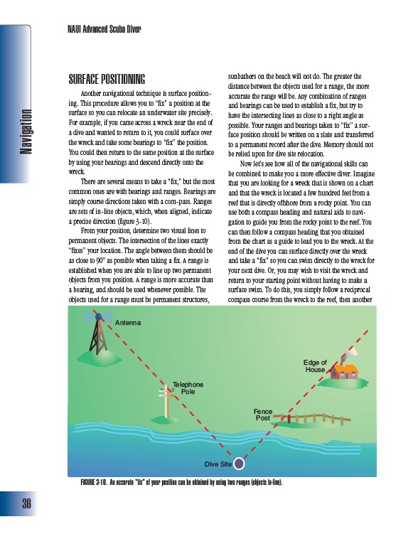
There are several means to take a “fix,” but the most
common ones are with bearings and ranges. Bearings are
simply course directions taken with a com-pass. Ranges
are sets of in-line objects, which, when aligned, indicate
a precise direction (figure 3-10).
From your position, determine two visual lines to
permanent objects. The intersection of the lines exactly
“fixes” your location. The angle between them should be
as close to 90° as possible when taking a fix. A range is
established when you are able to line up two permanent
objects from you position. A range is more accurate than
a bearing, and should be used whenever possible. The
objects used for a range must be permanent structures,
sunbathers on the beach will not do. The greater the
distance between the objects used for a range, the more
accurate the range will be. Any combination of ranges
and bearings can be used to establish a fix, but try to
have the intersecting lines as close to a right angle as
possible. Your ranges and bearings taken to “fix” a surface
position should be written on a slate and transferred
to a permanent record after the dive. Memory should not
be relied upon for dive site relocation.
Now let’s see how all of the navigational skills can
be combined to make you a more effective diver. Imagine
that you are looking for a wreck that is shown on a chart
and that the wreck is located a few hundred feet from a
reef that is directly offshore from a rocky point. You can
use both a compass heading and natural aids to navigation
to guide you from the rocky point to the reef. You
can then follow a compass heading that you obtained
from the chart as a guide to lead you to the wreck. At the
end of the dive you can surface directly over the wreck
and take a “fix” so you can swim directly to the wreck for
your next dive. Or, you may wish to visit the wreck and
return to your starting point without having to make a
surface swim. To do this, you simply follow a reciprocal
compass course from the wreck to the reef, then another
Antenna
Telephone
Pole
Dive Site
Fence
Post
Edge of
House
FIGURE 3-10. An accurate “fix” of your position can be obtained by using two ranges (objects in-line).