TYBEE BEACHCOMBER | JUNE 2018 7
By Allie Hayser
UNDER THE BLUE VIEW: WAVE SCIENCE
There’s a lot more motion and ocean going on than what we see from
our beach chairs. Waves, swell, underwater geology, currents, tides, and
winds: local beach goers and surfers can predict the best (day off) case
scenarios by understanding how these impact Tybee specifically and
checking popular forecasting apps/websites.
To understand Tybee from the ocean point of view, we should cover the
motions first. Where are these waves coming from? Waves are caused
by energy passing through water creating movement in a circular motion.
Weirdly put: waves are energy movement, not necessarily water movement.
From the beach, we see this energy movement crashing onto the sand or
as whitecaps out in the surf. These unseen orbital motions of the oceans
are being disturbed by the seafloor or caught by the surface winds, causing
the waves to break.
Our little island home has predictable wind patterns throughout the year:
Dec - Feb wind coming from the northeast and northwest, Mar - Aug wind
from the south, Sept - Nov wind from the northeast. The winds in the winter
and fall are much stronger and tend to lend us more surfing waves here
on Tybee. When winds blow over the surface of the ocean, the frictional
energy is transferred to the water and creates swell (a group of traveling
waves).
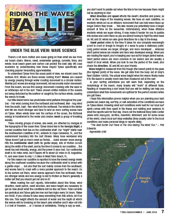
These moving groups of waves, aka swell, are affected by changes in
the topography of the ocean floor. Tybee Island lies in the Georgia Bight, a
curved coastline that lies on the continental shelf. Our “bight” starts near
the southeastern coastline of NC, extends to Cape Canaveral, FL, and the
easternmost boundary hits the Gulf Stream. Many have wondered why
Tybee doesn’t get as much swell as Florida… Quick answer: wave energy
hits the continental shelf (with its gentle slope), lots of friction occurs
along the width of the shelf, and by the time it comes to our coastline ... the
swell has lost intensity, energy, and the power it once had. Our continental
shelf is 80 miles wide, but it tapers off to about 63 miles in St. Augustine,
FL and even down to only 1.2 miles in West Palm Beach, FL.
For this reason our coastline is reported to have the lowest energy levels
along the southeast coastline because the continental shelf is broad with
a gentle slope … but also that the surf mainly comes from the southeast,
and waves tend to crash with a more parallel approach to the beach. So
to the surfers out there, when waves approach from the northeast, there
are stronger winds and less energy is lost to friction so there’s generally a
better bet that you should get out and on it!
When reading the surf reports, information about tide times, wind
direction, swell period, swell direction, and wave height are necessary to
get an idea about what the conditions will be like out there. Tidal currents
are periodical and Tybee gets two low and two highs every 24 hours. Tides
are HUGE, if you choose to take away something from this article, let it be
this one. Tide height affects the amount of water and the depth at which
the waves will be breaking on the beach (aka whether you’ll wipe out into
3-4 feet of freedom ... or 2 inches of exfoliation). Timing is key as well...
you don’t want to paddle out when the tide is too low because there might
not be anything to ride!
Wind direction and speed affects the swell’s direction and power, as
well as the shape of the breaking waves. We have an east coastline, so
westerly winds act as an offshore movement that can hold wave faces up
longer before they break … this also means you potentially have a longer
amount of time on the wave/ride. Unfortunately, when these offshore
westerly winds are super strong, it may make it harder for you to paddle
into waves and catch them as you are almost having to fight the wind head
on. NE and SE winds are also good directions for a day in the lineup.
Swell period refers to the time it takes for one complete wavelength
(crest to crest or trough to trough) of a wave to pass a stationary point.
Long period waves are larger, stronger, and more developed ... whereas
short period waves are smaller and have less developed energy. When you
are reading the report, you’re keeping your eye out for longer period waves.
Short period waves are more common in our waters and are usually a
result of local winds. When you look to see the period of the swell, also
check the direction. SE and NE are your friends.
Wave height is measured from the trough (the lowest point) to the peak
(the highest point) of the wave. We get data from the buoy out at Gray’s
Reef (Station 14008). The actual wave height when the waves finally make
it to the beach is usually much less than measured out at the reef.
In your surfing adventures you will learn that, depending on the
morphology of the beach, many breaks will “work” at different tides.
Reading or researching a surf break that you will be visiting can help you
understand what tide movements are optimal for the perfect session when
you get there.
I hope this information proves helpful when you are planning your next
paddle out, beach day, surf trip, or self-education of the conditions we have
on Tybee Island. Knowing what surf conditions work best for our local surf
spots comes with time spent in the lineup and relating your sessions to
what the reports said for that day. Check out the National Bouy Data Center
(www.ndbc.noaa.gov), Surfline, Swellinfo, WindAlert, and for some areas
of the world, check local surf shop websites (they usually cater to the local
conditions and make personal blogs or reports daily).
“The Best Surfer Out There Is The One Having The Most Fun.” ~ Phil
Edwards
Appreciate y’all!
/(www.ndbc.noaa.gov)