W E
Brevard County Odet
Philippe’s
homestead
MAY/JUNE 2016
9
| TAMPA BAY MAGAZINE 125
Division Bill presented by State Senator Donald C. McMullen
that, after being approved by the West Hillsborough voters,
resulted in Pinellas becoming our state’s 48th county.
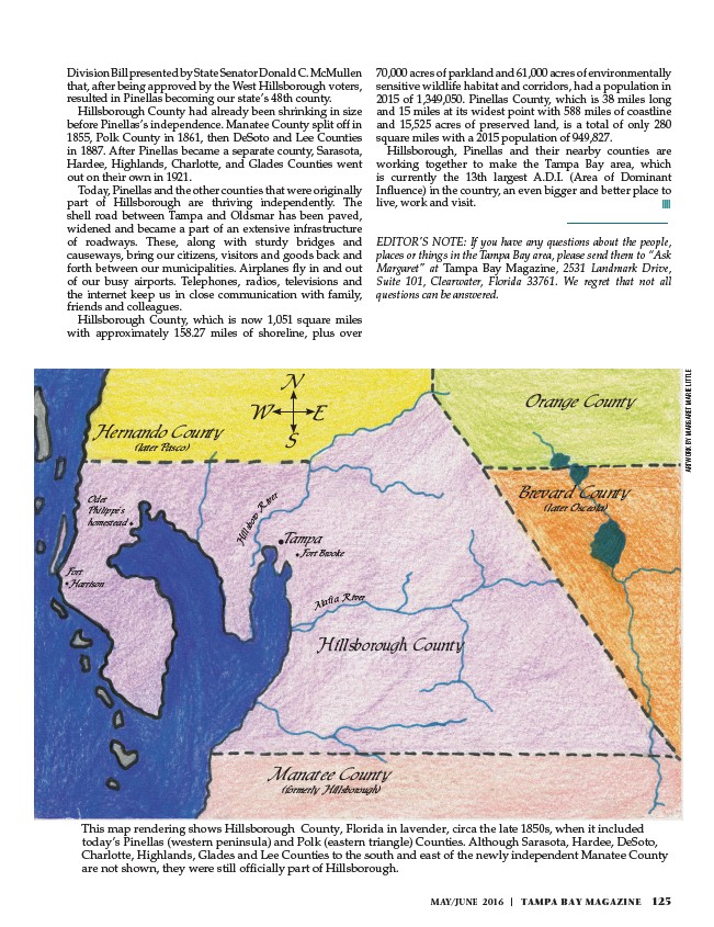
Hillsborough County had already been shrinking in size
before Pinellas’s independence. Manatee County split off in
1855, Polk County in 1861, then DeSoto and Lee Counties
in 1887. After Pinellas became a separate county, Sarasota,
Hardee, Highlands, Charlotte, and Glades Counties went
out on their own in 1921.
Today, Pinellas and the other counties that were originally
part of Hillsborough are thriving independently. The
shell road between Tampa and Oldsmar has been paved,
widened and became a part of an extensive infrastructure
of roadways. These, along with sturdy bridges and
causeways, bring our citizens, visitors and goods back and
forth between our municipalities. Airplanes fly in and out
of our busy airports. Telephones, radios, televisions and
the internet keep us in close communication with family,
friends and colleagues.
Hillsborough County, which is now 1,051 square miles
with approximately 158.27 miles of shoreline, plus over
70,000 acres of parkland and 61,000 acres of environmentally
sensitive wildlife habitat and corridors, had a population in
2015 of 1,349,050. Pinellas County, which is 38 miles long
and 15 miles at its widest point with 588 miles of coastline
and 15,525 acres of preserved land, is a total of only 280
square miles with a 2015 population of 949,827.
Hillsborough, Pinellas and their nearby counties are
working together to make the Tampa Bay area, which
is currently the 13th largest A.D.I. (Area of Dominant
Influence) in the country, an even bigger and better place to
live, work and visit.
EDITOR’S NOTE: If you have any questions about the people,
places or things in the Tampa Bay area, please send them to “Ask
Margaret” at Tampa Bay Magazine, 2531 Landmark Drive,
Suite 101, Clearwater, Florida 33761. We regret that not all
questions can be answered.
This map rendering shows Hillsborough County, Florida in lavender, circa the late 1850s, when it included
today’s Pinellas (western peninsula) and Polk (eastern triangle) Counties. Although Sarasota, Hardee, DeSoto,
Charlotte, Highlands, Glades and Lee Counties to the south and east of the newly independent Manatee County
are not shown, they were still officially part of Hillsborough.
ARTWORK BY MARGARET MARIE LITTLE
Hillsborough County
Manatee County
(formerly Hillsborough)
Hernando County
(later Pasco)
Orange County
Fort
Harrison
(later Osceola)
Alafia River
Hillsboro River
N
S
Tampa
Fort Brooke