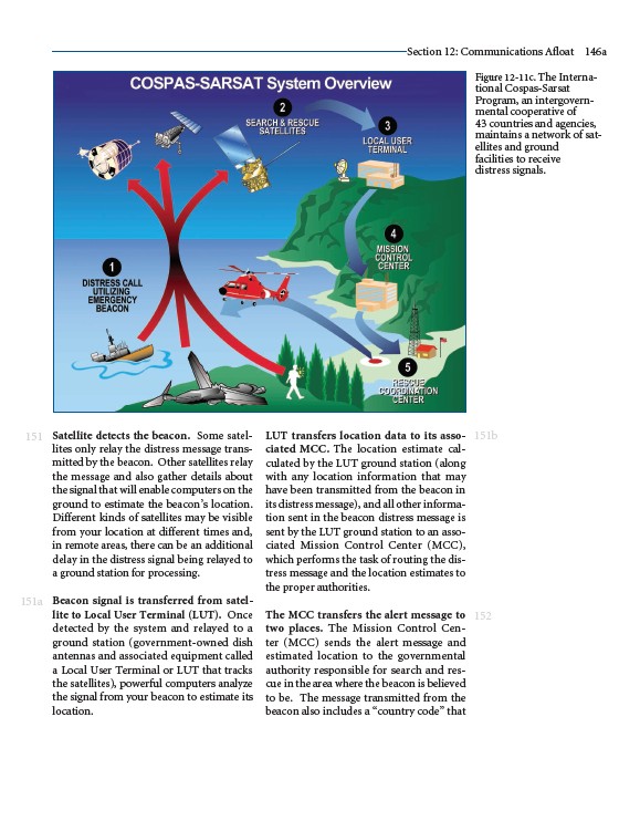
Satellite detects the beacon. Some satellites
only relay the distress message transmitted
by the beacon. Other satellites relay
the message and also gather details about
the signal that will enable computers on the
ground to estimate the beacon’s location.
Different kinds of satellites may be visible
from your location at different times and,
in remote areas, there can be an additional
delay in the distress signal being relayed to
a ground station for processing.
Beacon signal is transferred from satellite
to Local User Terminal (LUT). Once
detected by the system and relayed to a
ground station (government-owned dish
antennas and associated equipment called
a Local User Terminal or LUT that tracks
the satellites), powerful computers analyze
the signal from your beacon to estimate its
location.
Section 12: Communications Afloat 146a
LUT transfers location data to its associated
MCC. The location estimate calculated
by the LUT ground station (along
with any location information that may
have been transmitted from the beacon in
its distress message), and all other information
sent in the beacon distress message is
sent by the LUT ground station to an associated
Mission Control Center (MCC),
which performs the task of routing the distress
message and the location estimates to
the proper authorities.
The MCC transfers the alert message to
two places. The Mission Control Center
(MCC) sends the alert message and
estimated location to the governmental
authority responsible for search and rescue
in the area where the beacon is believed
to be. The message transmitted from the
beacon also includes a “country code” that
151
151a
Figure 12-11c. The International
151b
152
Cospas-Sarsat
Program, an intergovernmental
cooperative of
43 countries and agencies,
maintains a network of satellites
and ground
facilities to receive
distress signals.