62 Chapter Two
Section 5: Navigation Aids
Aids to Navigation can provide a boater
with information similar to that which
drivers get from street signs, stop signals,
road barriers, detours, and traffic lights.
This section will give you, the recreational
boater, the basic information you need
about the U.S. Aids to Navigation System
(USATONS). This information will help
you recognize, understand, and navigate
by the colors, shapes, numbers, sounds,
and lights you will encounter on the water.
USATONS are grouped by function:
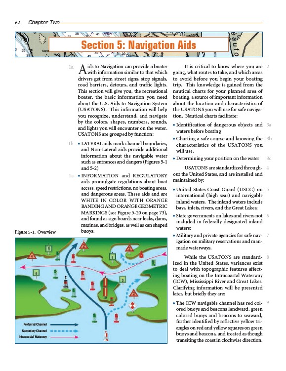
• LATERAL aids mark channel boundaries,
and Non-Lateral aids provide additional
information about the navigable water
such as entrances and dangers (Figures 5-1
and 5-2)
• INFORMATION and REGULATORY
aids promulgate regulations about boat
access, speed restrictions, no boating areas,
and dangerous areas. These aids and are
WHITE IN COLOR WITH ORANGE
BANDING AND ORANGE GEOMETRIC
MARKINGS (see Figure 5-20 on page 73),
and found as sign boards near locks, dams,
marinas, and bridges, as well as can shaped
buoys.
It is critical to know where you are
going, what routes to take, and which areas
to avoid before you begin your boating
trip. This knowledge is gained from the
nautical charts for your planned area of
boating, a source of important information
about the location and characteristics of
the USATONS you will use for safe navigation.
Nautical charts facilitate:
• Identification of dangerous objects and
waters before boating
• Charting a safe course and knowing the
characteristics of the USATONS you
will use.
• Determining your position on the water
USATONS are standardized throughout
the United States, and are installed and
maintained by:
• United States Coast Guard (USCG) on
international (high seas) and navigable
inland waters. The inland waters include
bays, inlets, rivers, and the Great Lakes;
• State governments on lakes and rivers not
included in federally designated inland
waters;
• Military and private agencies for safe navigation
on military reservations and manmade
waterways.
While the USATONS are standardized
in the United States, variances exist
to deal with topographic features affecting
boating on the Intracoastal Waterway
(ICW), Mississippi River and Great Lakes.
Clarifying information will be presented
later, but briefly they are:
• The ICW navigable channel has red colored
buoys and beacons landward, green
colored buoys and beacons to seaward,
further identified by reflective yellow triangles
on red and yellow squares on green
buoys and beacons, and treated as though
transiting the coast in clockwise direction.
1a
1b
1c
2
3a
3b
3c
4
5
6
7
8
9
Figure 5-1. Overview