210 Chapter Five
21
22
23
24
25
26
27
28
29
30
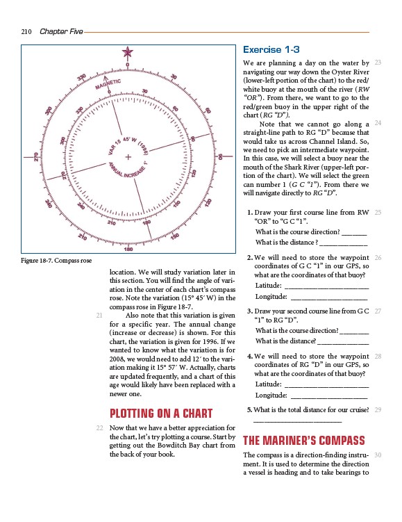
location. We will study variation later in
this section. You will find the angle of variation
in the center of each chart’s compass
rose. Note the variation (15° 45´ W) in the
compass rose in Figure 18-7.
Also note that this variation is given
for a specific year. The annual change
(increase or decrease) is shown. For this
chart, the variation is given for 1996. If we
wanted to know what the variation is for
2008, we would need to add 12´ to the variation
making it 15° 57´ W. Actually, charts
are updated frequently, and a chart of this
age would likely have been replaced with a
newer one.
PLOTTING ON A CHART
Now that we have a better appreciation for
the chart, let’s try plotting a course. Start by
getting out the Bowditch Bay chart from
the back of your book.
Exercise 1-3
We are planning a day on the water by
navigating our way down the Oyster River
(lower-left portion of the chart) to the red/
white buoy at the mouth of the river (RW
“OR”). From there, we want to go to the
red/green buoy in the upper right of the
chart (RG “D”).
Note that we cannot go along a
straight-line path to RG “D” because that
would take us across Channel Island. So,
we need to pick an intermediate waypoint.
In this case, we will select a buoy near the
mouth of the Shark River (upper-left portion
of the chart). We will select the green
can number 1 (G C “1”). From there we
will navigate directly to RG “D”.
1. Draw your first course line from RW
“OR” to “G C “1”.
What is the course direction? _______
What is the distance ? _____________
2. We will need to store the waypoint
coordinates of G C “1” in our GPS, so
what are the coordinates of that buoy?
Latitude: _______________________
Longitude: _____________________
3. Draw your second course line from G C
“1” to RG “D”.
What is the course direction? ________
What is the distance? ______________
4. We will need to store the waypoint
coordinates of RG “D” in our GPS, so
what are the coordinates of that buoy?
Latitude: _______________________
Longitude: _____________________
5. What is the total distance for our cruise?
_________________________
THE MARINER’S COMPASS
The compass is a direction-finding instrument.
It is used to determine the direction
a vessel is heading and to take bearings to
Figure 18-7. Compass rose