such as Eastern Europe or Asia, you will
need to count from left to right.
12. Write down the longitude in the format
ddd° mm.m’ W (or E) (i.e. 094* 49.5’W).
Skill—Plotting the GPS Reported
Position—Latitude and Longitude
on the Chart
This skill is required in order to plot your
present coordinates as reported by the GPS
onto the chart to determine your current
position. The steps will not be repeated as
this is the reverse process of measuring a set
of coordinates of an object plotted on the
chart.
EXERCISE 1-1
A sample chart for Exercise 1–1 can be
found at the back of this book. It should be
removed from the book for plotting.
A navigator must be able to identify a
position on a chart and determine the latitude
and longitude coordinates of a position
before entering a waypoint into a GPS.
Exercise 1-1 will demonstrate the
method of determining the latitude and
longitude of a given position. On the sample
chart:
• Measure and record position A.
• Measure and record positions B and C.
Course and Distance
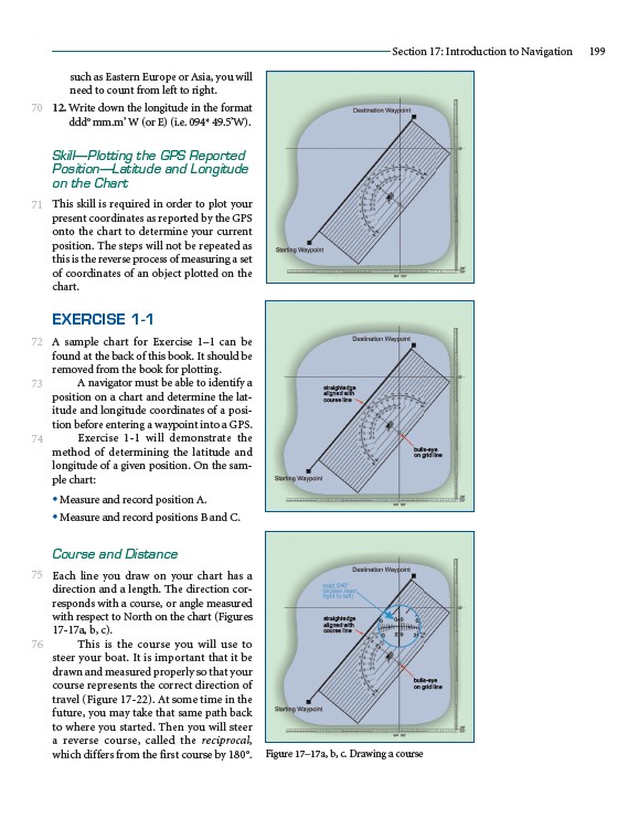
Each line you draw on your chart has a
direction and a length. The direction corresponds
with a course, or angle measured
with respect to North on the chart (Figures
17-17a, b, c).
This is the course you will use to
steer your boat. It is important that it be
drawn and measured properly so that your
course represents the correct direction of
travel (Figure 17-22). At some time in the
future, you may take that same path back
to where you started. Then you will steer
a reverse course, called the reciprocal,
which differs from the first course by 180°.
Section 17: Introduction to Navigation 199
70
71
72
73
74
75
76
straightedge
aligned with
course line
bulls-eye
on grid line
straightedge
aligned with
course line
bulls-eye
on grid line
Figure 17–17a, b, c. Drawing a course