INFORMATION AND
REGULATORY MARKS
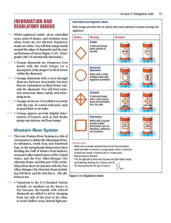
White regulatory marks show controlled
areas, areas of danger, and exclusion areas
where boats are not allowed. Regulatory
marks are white. You will find orange bands
around the edges of daymarks and the tops
and bottoms of buoys (Figure 5-20). (Paragraphs
108-110 intentionally eliminated.)
• Orange diamonds are Dangerous Area
marks with the word Danger (or a
description of the danger) in black letters
within the diamond.
• Orange diamonds with a cross through
them are Exclusion Area marks. You may
find an explanation in black letters outside
the diamond. You will find exclusion
areas near dams, rapids, and swimming
areas.
• Orange circles are Controlled Area marks
with the type of control indicated, such
as speed limit or no wake.
• Orange squares provide helpful information
of boaters, such as fuel docks,
pump-out stations, and boat ramps
Western River System
The term Western River Systems is a title of
convenience to define the Mississippi River,
its tributaries, South Pass, and Southwest
Pass, to the navigational demarcation lines
dividing the Gulf of Mexico from harbors,
rivers and other inland waters of the United
States, and the Port Allen-Morgan City
Alternate Route, and that part of the Atchafalaya
River above its junction with the Port
Allen-Morgan City Alternate Route including
Old River and the Red River. The differences
are:
• Variations to the U.S Standard System
include: no numbers on the buoys or
day beacons; day boards with colored
diamonds are added to aid in changing
from one side of the river to the other
to avoid shallow areas; limited light pat-
Section 5: Navigation Aids 73
Figure 5-20. Regulatory marks
107
111
112
113
113a
114
115