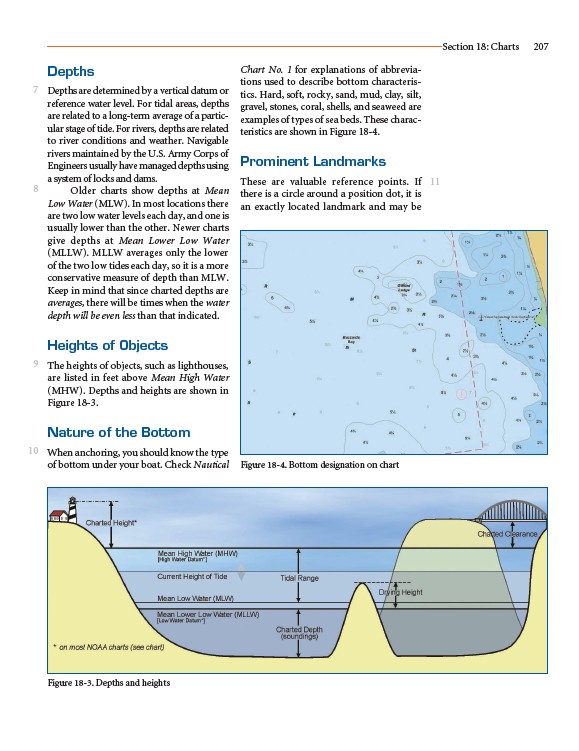
Depths
Depths are determined by a vertical datum or
reference water level. For tidal areas, depths
are related to a long-term average of a particular
stage of tide. For rivers, depths are related
to river conditions and weather. Navigable
rivers maintained by the U.S. Army Corps of
Engineers usually have managed depths using
a system of locks and dams.
Older charts show depths at Mean
Low Water (MLW). In most locations there
are two low water levels each day, and one is
usually lower than the other. Newer charts
give depths at Mean Lower Low Water
(MLLW). MLLW averages only the lower
of the two low tides each day, so it is a more
conservative measure of depth than MLW.
Keep in mind that since charted depths are
averages, there will be times when the water
depth will be even less than that indicated.
Heights of Objects
The heights of objects, such as lighthouses,
are listed in feet above Mean High Water
(MHW). Depths and heights are shown in
Figure 18-3.
Nature of the Bottom
When anchoring, you should know the type
of bottom under your boat. Check Nautical
Chart No. 1 for explanations of abbreviations
used to describe bottom characteristics.
Hard, soft, rocky, sand, mud, clay, silt,
gravel, stones, coral, shells, and seaweed are
examples of types of sea beds. These characteristics
are shown in Figure 18-4.
Prominent Landmarks
These are valuable reference points. If
there is a circle around a position dot, it is
an exactly located landmark and may be
Section 18: Charts 207
7
8
9
10
11
Figure 18-3. Depths and heights
Figure 18-4. Bottom designation on chart