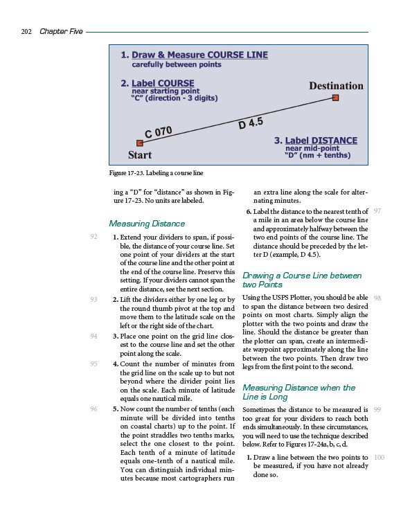
ing a “D” for “distance” as shown in Figure
17-23. No units are labeled.
Measuring Distance
1. Extend your dividers to span, if possible,
the distance of your course line. Set
one point of your dividers at the start
of the course line and the other point at
the end of the course line. Preserve this
setting. If your dividers cannot span the
entire distance, see the next section.
2. Lift the dividers either by one leg or by
the round thumb pivot at the top and
move them to the latitude scale on the
left or the right side of the chart.
3. Place one point on the grid line closest
to the course line and set the other
point along the scale.
4. Count the number of minutes from
the grid line on the scale up to but not
beyond where the divider point lies
on the scale. Each minute of latitude
equals one nautical mile.
5. Now count the number of tenths (each
minute will be divided into tenths
on coastal charts) up to the point. If
the point straddles two tenths marks,
select the one closest to the point.
Each tenth of a minute of latitude
equals one-tenth of a nautical mile.
You can distinguish individual minutes
because most cartographers run
an extra line along the scale for alternating
minutes.
6. Label the distance to the nearest tenth of
a mile in an area below the course line
and approximately halfway between the
two end points of the course line. The
distance should be preceded by the letter
D (example, D 4.5).
Drawing a Course Line between
two Points
Using the USPS Plotter, you should be able
to span the distance between two desired
points on most charts. Simply align the
plotter with the two points and draw the
line. Should the distance be greater than
the plotter can span, create an intermediate
waypoint approximately along the line
between the two points. Then draw two
legs from the first point to the second.
Measuring Distance when the
Line is Long
Sometimes the distance to be measured is
too great for your dividers to reach both
ends simultaneously. In these circumstances,
you will need to use the technique described
below. Refer to Figures 17-24a, b, c, d.
1. Draw a line between the two points to
be measured, if you have not already
done so.
202 Chapter Five
92
93
94
95
96
97
98
99
100
Figure 17-23. Labeling a course line